Dramatic satellite video shows fire and smoke from roaring blazes across more than a million acres of the U.S. West
Author Vishay SinghPosted on Categories Discover Magazine
Smoke from the fires appears to have blown all the way across North America and more than half way across the Atlantic
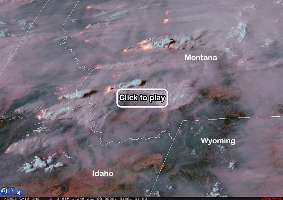
Smoke and heat from raging wildfires in Idaho and Montana are seen in this animation of satellite images acquired on Sept. 3, 2017. (Source: RAMMB/CIRA)
As of this afternoon, 77 large fires are burning across 1.4 million acres in eight western U.S. states. That’s an area more than three times the size of Houston.
The burning is part of a long-term trend of increasing wildfire in the West, brought on by human-caused climate change.
Hardest hit by fire right now is Montana, with 26 large wildfires blazing today across 662,105 acres, according to the the National Interagency Fire Center. The animation above, consisting of imagery acquired by the GOES-16 weather satellite on September 3, 2017, shows enormous amounts of heat rising many of those fires, detected in the infrared, along with massive plumes of smoke.
Smoke from the fires has been smothering vast swaths of territory. I’ve been looking at a variety of satellite imagery and to my eye it seems that smoke from the western U.S. fires (possibly mixed with smoke from Canadian wildfires) has blown all the way across North America, out over Greenland and across more than half of the Atlantic Ocean.
The following animation of imagery, also acquired by GOES-16, shows the extent of the smoke as day broke across North America today. I’ve circled the smoke in the screenshot. Click on the image to watch the animation. The smoke turns up in something of a salmon color:
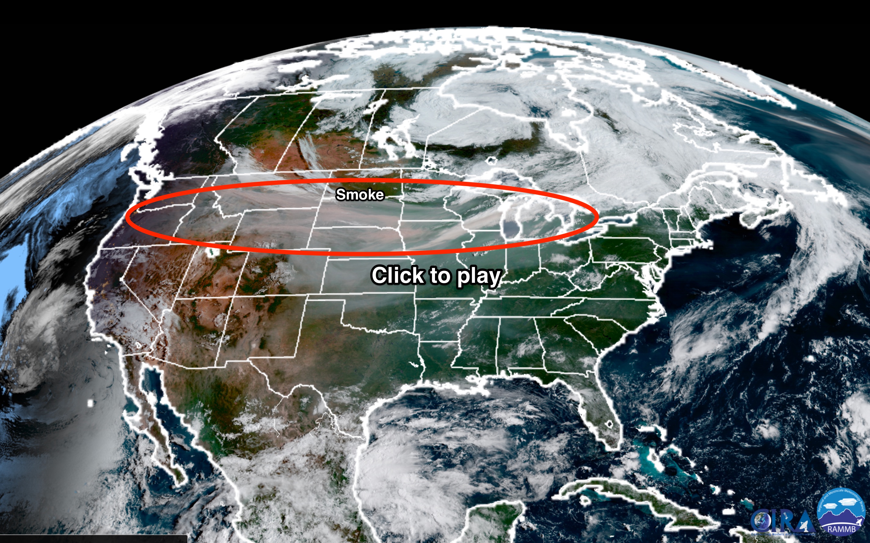
An animation of GOES-16 satellite imagery acquired early on Monday, Sept. 4, 2017, shows huge amounts of smoke blowing across much of North America. (Source: RAMMB/CIRE)
If you look in the upper right corner in the animation, you might be able to spot some smoke blowing out over the Atlantic.
In the next animation, covering the past six days, you can watch the progress of the smoke across North America and out into the Atlantic:

This animation shows satellite measurements of aerosol amounts in the atmosphere over North America and the North Atlantic Ocean between Aug. 30 and Sept. 4, 2017. (Source: NASA Worldview)
The animation is created using data acquired by the Moderate Resolution Imaging Spectroradiometer, or MODIS, on NASA’s Terra satellite. It shows aerosols in the atmosphere, with redder tones indicative of higher concentrations. These tiny particles can come from a variety of sources, including dust, sea salts, volcanic ash, pollution – and smoke from wildfires.
As you watch the animation, follow the red as it spreads across the continent and then out into the Atlantic south of Greenland (which is visible in the upper right). The first frame, acquired on Aug. 30th, and the last frame captured today (Sept. 4), linger longer than the others.
If you’re wondering why the last frame shows only a small part of North America, that’s because as I’m writing this post on Monday afternoon, Terra has not yet imaged the rest of the continent.
Here’s a before and after view over the Atlantic from the Meteosat-10 satellite showing what I think is very likely smoke from the wildfires:

An animation consisting of Meteosat-10 satellite images acquired on Aug. 29 and Sept. 3, 2017. (Source: EUMETSAT)
This imagery consists of data acquired in the visible and near-infrared part of the electromagnetic spectrum. In these kind of views from Meteosat-10, smoke typically appears in bluish tones and is more visible in the early morning or late evening. The images in this animation were acquired as evening approached on Aug. 29 and Sept. 3, 2017.
In the Aug. 29th view, a faint light-bluish cast can be seen below Greenland’s southern tip. By Sept. 3, the bluish cast, which I’ve circled in red, is far more pronounced.
Lastly, a more personal view of the impact of the smoke: I had to bag my run this morning here in Niwot, Colorado because of particle pollution from smoke blowing in from the west. It was so bad that the Rocky Mountains, normally visible from near my house, were totally obscured.
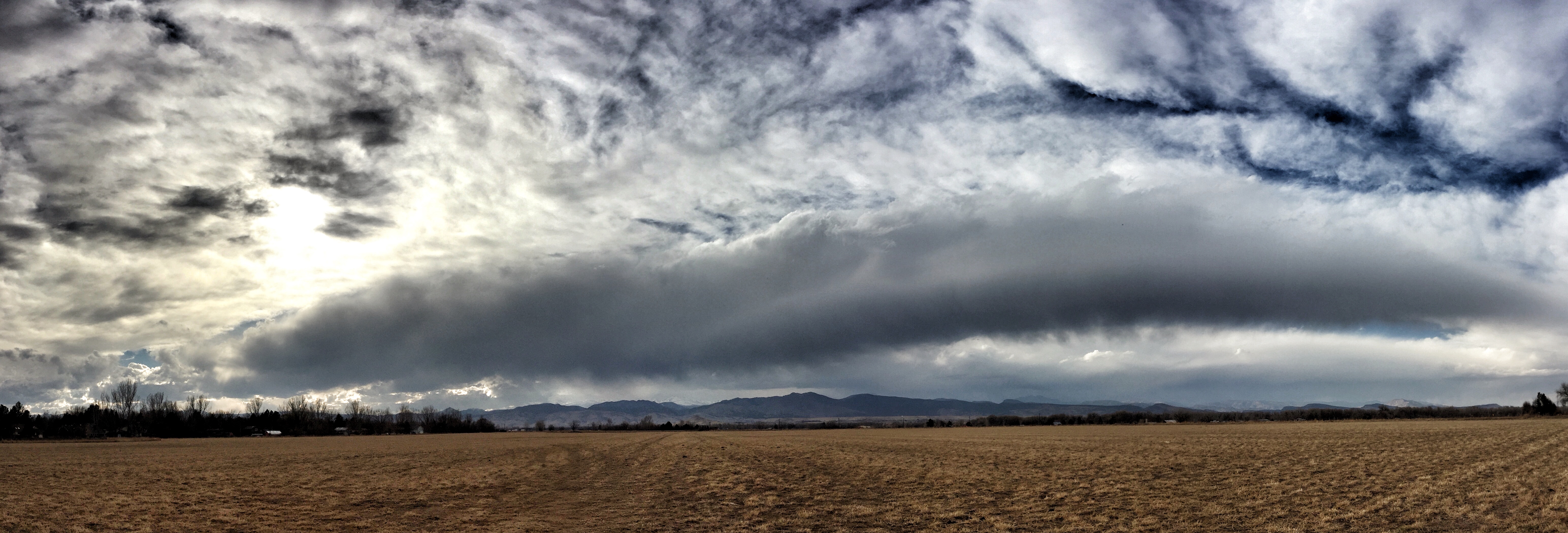
A mosaic of iPhone photos looking west from Niwot on Feb. 19, 2017 (Image: © Tom Yulsman)
The photo-mosaic above shows the view from a trail near my house on a day when the atmosphere was free from smoke. The foothills of the Rockies are clearly visible on the horizon (with a beautiful elongated cloud above them).
And here’s the view from this morning:

Smoke from western wildfires visible in Niwot on Sept. 4, 2017 (Photo © Tom Yulsman)
This one is just a single photo, not a mosaic of several like the previous image. But it was taken in roughly the same spot. And as you can see, no mountains are visible.
I’ve seen conditions like this when wildfires were burning closer to home, in western Colorado. But never this bad from fires that are 800 miles and more away.
Since the beginning of this year, 46,951 fires have burned across 7,650,844 acres of the United States, according to the National Interagency Fire Center. For the prior 10 years (2006-2016), the annual average has been 5,488,788 acres. So eight months through 2017, we’ve already beaten the average for an entire year by nearly 40 percent. And we still have quite a ways to go before fire season ends — if it ends…
Research shows that wildfire activity in the western United States has increased dramatically, thanks to our emissions of greenhouse gases. Among the latest research is a study published last year in the Proceedings of the National Academy of Sciences. The findings were summarized in a news release from Columbia University’s Earth Institute:
. . . human-induced climate change has doubled the area affected by forest fires in the U.S. West over the last 30 years. According to the study, since 1984 heightened temperatures and resulting aridity have caused fires to spread across an additional 16,000 square miles than they otherwise would have—an area larger than the states of Massachusetts and Connecticut combined. The authors warn that further warming will increase fire exponentially in coming decades.
This year’s fire behavior may be just a foretaste of what’s to come.