Volcanoes and Glaciers Seen from Space
Posted on Categories Discover Magazine

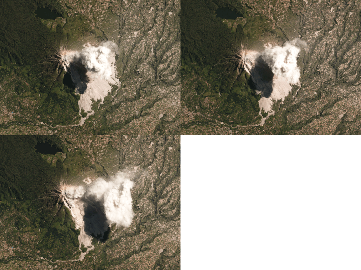
A July 2017 eruption of Sinabung in Indonesia captured as it happened by Earth-observing “Doves” launched by Planet Labs. Image by Planet Labs (CC BY-SA 4.0)
One of the most exciting aspects of geosciences in the 21st century is the ability to watch geologic events from space. We can see an eruption or earthquake as it happens—sometimes catching it in the act. We can also roll back the film and look at what things were like in images taken beforehand. It is one of the most fundamental changes to how we look at earth processes since we were able to go the other way and see rocks at a microscopic level.
Here are two great examples. The first is a GIF of a small eruption at Sinabung in Indonesia. If you aren’t familiar with Sinabung, it sits near the Toba caldera—the volcano that produced the largest volcanic eruption in the last 100,000 years. Now, Sinabung is a small fry compared to Toba, but it is one of the largest volcanic humanitarian crises today. People have been evacuated from their homes near the volcano for over 5 years and most have had to live in “temporary” shelters.
Sinabung produces some of the deadliest of volcanic products: pyroclastic flows. These flows are avalanches of hot volcanic debris moving down the volcano at hundreds of kilometers per hour. They can run out for kilometers around the volcano and destroy everything and everyone in their path. The best examples are pyroclastic flows that buried Pompeii during the 79 AD eruption of Vesuvius.
Now, Sinabung has been growing a lava dome near its summit for years and as it gets too steep, it collapses. This collapse produces an explosion and pyroclastic flow. That’s what we see in the images above: a puff of an eruption and pyroclastic flows moving down the volcano. You can see the area on the lower right hand side of the volcano that has been covered in volcanic debris (also known as tephra) over the years. Those squares on three sides of Sinabung are fields and homes … so people still live close to the volcano!
This ash doesn’t just linger on the slopes of the volcano. It can be moved as volcanic mudflows (lahars) years after the eruption. You can see the river channel at the bottom that is carrying volcanic debris away from the volcano, sometimes as these potentially deadly mudflows.

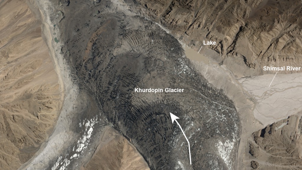
Khurtopin Glacier in Pakistan, seen during August 2017. The arrow shows the direction the glacier is surging, blocking the flow of the river to create the small lake. Image by Planet Labs (CC BY-SA 4.0)
Another example is this high-resolution image of Khurdopin Glacier in Pakistan (above). The glacier is surging down the valley it occupies into the channel of the Shimshal River. This blocks the river creating a small pond behind the glacier. However, glaciers melt, so these ponds are a high hazard for producing floods when the ice dam fails.
You might wonder, “Wait, if glaciers are ice, why is this one dark?” Glaciers actually carry a lot of rocks, so Khurdopin Glacier is moving piles of dark, rocky sediment on top of the ice that you can see through the cracks and crevasses. You can read more about this phenomenon in this great explanation by the NASA Earth Observatory.
These observations give use rich details of geologic features that would be very difficult to monitor as they are in remote locations. Imagery like this can be used to help watch the state of the glacier and lake and possibly be used to assess how much of a hazard this represents.