A Tour of the Cascade Volcanoes from Space: Oregon
Author Vishay SinghPosted on Categories Discover Magazine
The Oregon Cascade Range is … complicated. From the surface it looks like the chain of volcanoes that we started exploring back in British Columbia remains the same. However, once you start looking at the deep geologic processes that are causing volcanoes in Oregon, you quickly realize there is a lot going on.
“How much?” you say? Here’s a short list:
-
The Juan de Fuca plate is still subjecting (sliding underneath) North America just off the Pacific Coast.
-
Much of the basin that follows the Columbia River is filled with basalt lava from the largest flood basalt period in the last 50 million years.
-
The high Cascades from Hood to Three Sisters sit in a graben (valley) with faults bounding both sides of the range.
-
Multiple major fault zones intersect the Cascade Range.
-
The High Lava Plains – a ~10 million year old chain of rhyolite and basalt volcanism that gets younger to the west — intersect the Cascade Range near Bend, Oregon
-
The Basin & Range — the province that creates the mountain belts and valleys in western North American — starts in the southern part of Oregon just to the east of the Cascade Range.
We’re not going to get into the “why” of all this, but the volcanism along the Oregon Cascade Range is definitely influenced by a bevy of these tectonic factors. The other fun thing about the Oregon Cascade Range is that I do a lot of my research there, so I think a lot about them.
As usual, you can find the high resolution version of these Sentinel-2 images here.
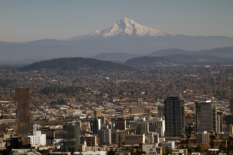
Mt. Hood (Wy’East*)
Mt. Hood in Oregon seen on September 14, 2023 by ESA’s Sentinel-2 satellite. Credit: ESA.
Mt. Hood is to Portland what Mt. Rainier is to Seattle: an ever-present sentinel that both makes a beautiful backdrop and an ominous neighbor. Few people in the Portland area likely realize that Hood erupted as recently as 1865! If you have ever spent time at Mt. Hood and its famous Timberline Lodge, you can see the remnants of some of the activity over the past 250 years up near the summit. On top of that, the river channels leading from Hood, especially on the south side, are choked with volcanic debris that was carried there by pyroclastic flows and volcanic mudflows.
All this adds up to Hood landing at #6 on the USGS ranking of the most potentially dangerous volcanoes in the United States, making it the #4 most hazardous in the Cascade Range. Earthquakes swarms are relatively common near Mt. Hood, but they are usually related to a set of faults that run on the south side of the volcano. Hood is also home to a couple small glaciers, adding to the potential threat of volcanic mudflows both during and in-between eruptions.
Mt. Jefferson (Seekseeksqua)
Mt. Jefferson in Oregon seen on October 6, 2023 from ESA’s Sentinel-2. Credit: ESA.
Mt. Jefferson, the remote volcano in the central Oregon Cascades, was once of the largest along the west coast of North America. The last Ice Age did a number on Jefferson, leaving it a craggy mass of lava flows and volcanic debris. Eruptions from Jefferson itself may have last occurred during that last Ice Age around 15,000 years ago. Those eruptions were big, sending ash as far east as present-day Idaho.
Even if eruptions from the main volcano haven’t occurred for thousands of years, there are some related cinder cones south of Jefferson erupted as recently as 950 CE. Jefferson is also covered in snow much of the year, so volcanic mudflows are always a potential hazard, especially if they were to make it down to reservoirs like Detroit Lake and Lake Billy Chinook.
Belknap Crater and Collier Cone
The Belknap Crater area in central Oregon. Collier Cone and its long lava flow can be seen in the lower portion of the image. Seen on October 4, 2023. Credit: ESA.
The Central Oregon Cascades are full of basaltic shield volcanoes, lava flows and scoria cones. That’s weird. In fact, some of the most voluminous activity along the Cascade Range has not been from the big volcanoes like Mount St. Helens but rather from lava flow fields in Central Oregon. Lava flows in the past 3,000 years from a number of small volcanoes and fissures in the area of McKenzie Pass has sent lava almost 10 miles down the McKenzie River valley.
Volcanic activity like what we see at Belknap Crater and Collier Cone (a cinder cone on the slopes of North Sister that formed ~1,500 years ago) are not common in continental subduction zones like the Cascades. One idea is that faulting across central Oregon as part of the complex tectonics I mentioned above has allowed this basalt lava to make it to the surface more easily than other subduction zones like the Andes.
The most recent activity at Belknap Crater was only ~1,500 years ago and the oddly Moon-like landscape can be explored if you drive across the McKenzie Highway. The nearby Sand Mountain volcanic field erupted only ~1,050 years ago.
Three Sisters (Klah Klahne)
Three Sisters seen by Sentinel-2 on September 24, 2023. Credit: ESA
The Three Sisters in Central Oregon is one of my very favorite places anywhere. Very few places on Earth pack so much volcanic variety than the Three Sisters region. You can find basaltic andesite lava flows and cinder cones, giant composite volcanoes (three of them!), rhyolite domes, huge pumice and ash deposits, glaciers and more.
The Sentinel-2 image captures most of the Three Sisters region. The actually Three Sisters themselves — North, Middle and South Sister — are the large arc volcanoes that (in general) get younger as you head south. The area just to the east of South Sister is Broken Top, an ancestral volcano that was active over 150,000 years ago. The weird pancake-looking things just to the south of South Sister are the Devils Hills and Rock Mesa, gooey rhyolite domes that erupted only ~2,000-2,200 years ago.
Interestingly, even though the Three Sisters have seen eruptions just to the north and south of the chain over the past few thousand years, there has been no identified eruption from the main Sisters for likely at least the last 20,000 years. That being said, South Sister is one of the only Cascade Range volcanoes that has shown any deformation related to magma intruding under the volcano in the 21st century.
Newberry Caldera
Newberry Caldera in Central Oregon seen by Sentinel-2 on October 6, 2023. Credit: ESA.
Newberry Caldera might not be in the same lineup as the Cascade Range, but its eruptions have shaped the area around Bend. A stone’s throw from the Three Sisters, Newberry has actually erupted more recently and more frequently over the last 10,000 years than its nearby Cascade Range neighbor.
The big grey lump on the south side of the Newberry Caldera is the aptly named “Big Obsidian Flow” that erupted only 1,300 years ago. It became one of the largest sources of obsidian for Native American people living in the Pacific Northwest.
The twin lakes in Newberry Caldera — Paulina and East Lakes — are separated by another small obsidian flow and cinder cone. Hot springs still persist on the shores of the lakes as well.
Newberry has more up its sleeve as well. Much of the area around the caldera is covered by basaltic andesite lava flows related to the magmatic system at Newberry, erupting as fissures and cinder cones along faults that cross the area. The Northwest Rift Zone of Newberry created a volcanic landscape of dark lava flows that includes Lava Butte, a small cinder cone right off of highway 97.
Newberry is the site of one of the more prominent “hot rock” geothermal energy prospects in the United States as well. Altarock Energy has been working on enhanced geothermal systems development where flow of fluids in the subsurface are made easier by breaking the rocks.
Crater Lake (Giiwas)
Crater Lake in Oregon seen by Sentinel-2 on October 4, 2023. Credit: ESA
Up until ~7,600 years ago, southern Oregon had its equivalent to Mt. Hood. Now, it has one of the most stunning lakes in the world. Crater Lake is the product of the largest known eruption in the Cascade Range: the 5,680 BCE cataclysmic eruption of Mt. Mazama (as we refer to the past mountain). This eruption was large enough to empty the innards of the volcano, leaving the mountain with no foundation so to speak.
The whole thing collapsed like a piston over the course of likely a few days. This transformed a ~11,000-12,000 foot volcano into a caldera that was over 2,000 feet deep (or ~5,000 feet above sea level). That’s 7,000 feet of elevation loss! Over 50 cubic kilometers of volcanic ash and debris erupted during the VEI 7 eruption, putting the eruption on the same scale as Tambora in 1815.
Wizard Island is the small cinder cone that formed inside the caldera a few hundred years after the massive eruption. A few other eruptions have happened since the 5,680 BCE blast, but they lie beneath the surface of the lake. Crater Lake hasn’t likely seen any eruptions in the past ~6-7 thousand years, but a little bit of that residual heat from the magmatic system below still leaks out in the form of vents at the bottom of the lake.
Next time, we’ll look at the Cascades of Northern California and think about what the future will bring for the Cascade Range.