Stunning Satellite Images Reveal the Power and Immensity of Hurricane Helene
Author Vishay SinghPosted on Categories Discover Magazine
Hurricane Helene has been rampaging through the southeastern United States today, causing catastrophic flooding and killing at least 40 people in four states. The death toll is likely to rise.
The storm slammed ashore as a Category 4 hurricane on Thursday evening with maximum sustained winds of 140 mph. It also pushed up inundating storm surges. As I’m writing this on Friday afternoon, it has been downgraded to a tropical storm — but it still poses deadly dangers.
“Historic, catastrophic and life- threatening flash and urban flooding, including numerous significant landslides, will continue across portions of the Southern Appalachians through this evening,” according to the National Hurricane Center.
Including Helene, the United States has now experienced a record eight Category 4 or Category 5 Atlantic hurricane landfalls in the past eight years (2017-2024). “That’s as many Cat 4 and 5 landfalls as occurred in the prior 57 years,” writes meteorologist Jeff Masters.
Hurricanes feast on oceanic heat and turn it into the energy of their winds. “A hotter ocean will allow hurricanes to grow more powerful, assuming that the other factors that power hurricanes, including low wind shear and a moist atmosphere, are present,” according to Masters.
As it turns out, this time there was record-setting heat for Helene to devour, which of course is linked to climate change. But before I delve into more detail on possible climate connections, check out this round-up of remote sensing imagery of the storm, highlighting some of its significant features:
GOES-16 Satellite Imagery
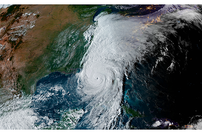
Hurricane Helene’s astonishing evolution over the course of just two and a half days is seen in this animation of GOES-16 satellite images — from a tropical disturbance in the Caribbean Sea to a devastating Category 4 hurricane along Florida’s Gulf of Mexico coastline. (Credit: CSU/CIRA & NOAA).
As viewed by the GOES-16 satellite, Helene evolves into a Category 4 storm with an eye wall crackling with lightning. (Credit: CSU/CIRA & NOAA).
Hurricane Helene makes landfall on Sept. 26, 2024 as a Category 4 storm with maximum sustained winds of 140 mph in Florida’s Big Bend region, as seen in this infrared view acquired by the GOES-16 satellite. (Credit: CSU/CIRA & NOAA).
A 12-hour time lapse of GOES-16 satellite imagery shows Hurricane Helene making landfall, and charging inland, where it has triggered catastrophic rainfall and deadly inundation. (Credit: CSU/CIRA & NOAA).
Back to Climate Connections…
Even before anything had really happened, hurricane experts were worried. As the University of Miami’s Brian McNoldy put it on Sept. 17, “There is nothing to look at yet, but a broad low pressure system could take shape on Friday-Saturday east of Honduras then consolidate and track north from there.”
McNoldy and others were concerned because of the record-setting hurricane fuel in the western Caribbean — sky-high oceanic warmth. “All of this means that should anything form in the western Caribbean soon, the ocean will provide endless high-octane fuel for it.”
Ocean heat content — meaning the thermal energy stored in a volume of the ocean — has been running at record-high values in the Caribbean Sea. (Credit: Brian McNoldy, University of Miami)
As we now know, something did indeed form — a disturbance that exploded into Hurricane Helene at a breathtaking pace.
But on Sept. 23, Helene had not yet turned into a bona fide storm. Even so, McNoldy was growing increasingly concerned, and he predicted the disturbance would very likely intensify rapidly once it entered the Gulf of Mexico.
“Not only is the sea surface temperature along its path a toasty 30-31C, the warm water runs deep, producing extremely high ocean heat content… an endless source of fuel,” he wrote. “A warm ocean isn’t everything when it comes to hurricanes, but it’s a lot.”
As the storm moved from the Caribbean into the Gulf of Mexico, it seems to have fed on a large, tongue-shaped patch of particularly warm water, which you can see here:
A tongue-shaped patch of unusually warm water is seen here extending into the Gulf of Mexico on Sept. 23, 2024. The visualization was created using data from satellites and instruments on the surface. (Credit: NASA Worldview.)
The warm tongue extended north from the Caribbean Sea into the Gulf of Mexico toward the Florida Panhandle. It was a sign that the Loop Current, which helps funnel water from the Caribbean into the Gulf of Mexico, had shed a warm eddy “that was lingering uncomfortably close to U.S. shores,” according to NASA.
As McNoldy predicted, Helene intensified very rapidly, sped quickly landward, and then charged deeply inland.
And as we’ve seen, it has dumped enormous amounts of water, leading to calamitous flooding. Here, too, there is a possible climate connection. That’s because warming spurs increased evaporation of water into the air, which in turn can hold more water vapor when it’s warmer. The result: juiced up rainfall. Moreover, as the water vapor condenses into liquid, it releases heat, which can help sustain the entire chain of events.
We don’t know yet just how much climate change affected Helene. So in the weeks ahead, scientists will likely produce “attribution” studies that can potentially shed more light on the connections between Helene and climate change. Stay tuned for those.
In the meantime, for more detail on this subject, I highly recommend Jeff Masters’ in-depth look: “Four ways climate change likely made Hurricane Helene worse“