Team of Top Scientists Prepare to Invade Antarctica's Scariest Glacier
Author Vishay SinghPosted on Categories Discover Magazine
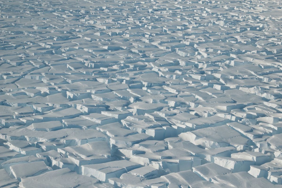
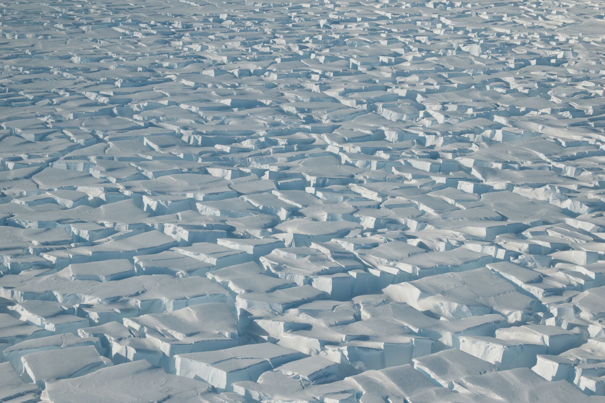
A photo of Thwaites taken during a reconnaissance flight. (Credit: U.S. National Science Foundation)
An elite team gathered in the United Kingdom on Monday to plot their plan of attack in a daring effort to hold off a global catastrophe. No, it isn’t the latest Avengers flick. This group, roughly 100 strong, consists of some of the world’s top polar scientists. And their quarry is an absolutely massive chunk of ice. They’re calling it the Thwaites Invasion.
Of all the glaciers in Antarctica threatened by climate change, scientists have recently grown especially concerned about one in particular. This Florida-sized glacier, called Thwaites, holds enough ice to single-handedly raise sea levels by several feet — enough to flood communities from Miami to Atlantic City.
And there are signs that it’s already begun an irreversible collapse.
Getting the Team Together
So today, the United States and the United Kingdom launched a roughly $50 million campaign to poke, prod, scan and survey every mile of this mammoth glacier. The project is the largest joint effort the two nations have conducted in Antarctica since mapping the continent in the 1940s.
Some $25 million will be spread among eight teams of international scientists, with each group assigned a specific set of problems. The rest of the money supports the daunting logistics of working in one of the harshest and most remote places on the planet.
Because solid data on the glacier is lacking, their goal is to answer two questions: How much? How fast?
“We want to bring those error bars down so the data is as useable as it can be for people who live on the coast,” says the National Science Foundation’s Paul Cutler, who’s managing the Thwaites program.
For Antarctic researchers, Thwaites’ fate is among the biggest unknowns on the continent.
About a decade ago, scientists began a major campaign to better understand Thwaites’ neighboring glacier, Pine Island. Their results showed it was melting alarmingly fast. And a great amount of attention has since been focused on Pine Island. But in recent years, data gathered by satellites and aerial surveys from NASA’s Operation IceBridge, have uncovered signs of trouble at Thwaites and other smaller glaciers in the Amundsen Sea region. The glaciers here are melting faster than anywhere else on Earth.
And scientists’ worries have only increased as they find out more about the terrain beneath Thwaites. The glacier is wide, and it sits in a basin that gets deeper as it goes inland. That means that as relatively warm ocean water washes in and melts the glacier’s front, it will recede back into deeper water – melting faster and faster. The ice in just that basin could cause 3 feet of global sea level rise.
“There’s nothing we know about that would stop it from retreating quite far back into the basin,” Cutler says.
The coastal glaciers along the Amundsen Sea hold back inland glaciers that are also below sea level. So when they collapse, it could set off the collapse of the larger West Antarctic Ice Sheet, bringing catastrophic sea level rise.
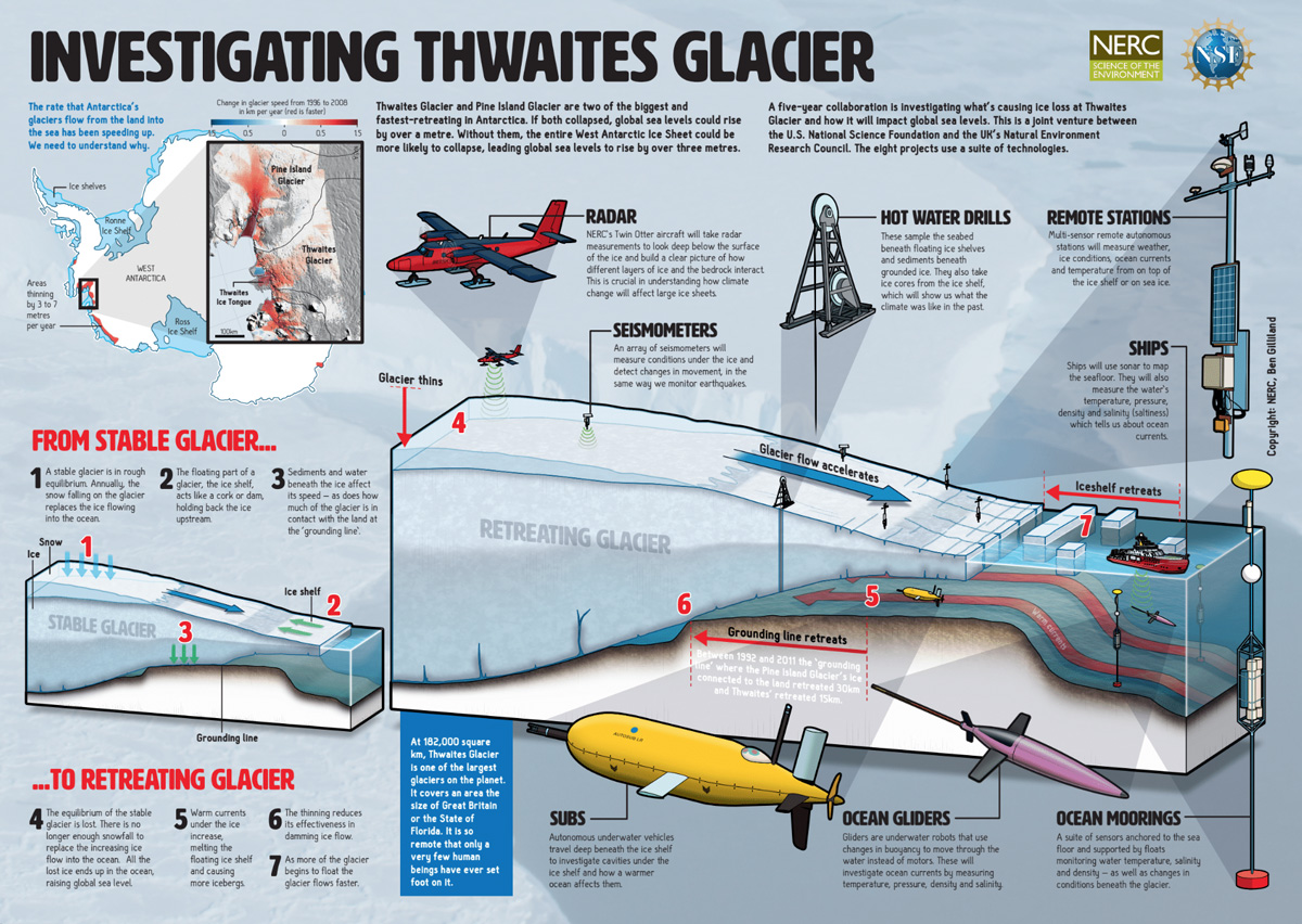
Click to enlarge. (Credit: U.S. National Science Foundation)
However, while a range of models point to Thwaites’ eventual collapse, a lack of fine detail in the data means those predictions currently offer drastically different results. Some models show Thwaites’ collapse will take a number of decades, others indicate perhaps several centuries.
“There are still many aspects of the ice and ocean that cannot be determined from space,” the National Snow and Ice Data Center’s Ted Scambos, who’s coordinating the project said in an announcement. “We need to go there, with a robust scientific plan of activity, and learn more about how this area is changing in detail, so we can reduce the uncertainty of what might happen in the future.”
Erin Petitt of the University of Alaska Fairbanks is on one of the eight teams spearheading the Thwaites Invasion. Her team will focus on how the ocean and the atmosphere drive Thwaites’ melting. To do that, they’ll venture out onto the ice shelf to install remote weather stations. They’ll drill a hole through thousands of feet of ice to deposit instruments in the ocean below. And they’ll tap a submarine drone – the famous Boaty McBoatface – to explore conditions beneath the floating shelf.
Petitt says that one of the top priorities is to study the channels carved into the bottom of the ice shelf that allow warm water to wash in and melt Thwaites from below.
“That’s the key to how much you can melt, how fast,” she says. It may be that these channels allow warm ocean water to rush in, but also quickly funnel it back out to sea. Like an old school finned furnace in your house, the shape and structure governs how well heat transfers.
Comprehensive Plan of Attack
Each of the other seven projects have similarly complex mandates, with many of them venturing far out onto the ice shelf. The field campaign will also involve extensive sea, airplane, helicopter and space-based surveys, all aiming to get a better idea of the ice shelf’s structure.
This large, international project will join the ranks of other big Antarctic science projects, like the IceCube neutrino detector and the WISSARD drilling project that found life in a glacial lake half a mile below the surface. But the Thwaites invasion ranks as the largest-ever field study of sea level rise, officials say.
Officials say the two governments noticed scientists from both countries were submitting similar funding requests, so it made sense to develop a joint effort. The collective callout for proposals attracted applications from top scientists around the world. Beyond sharing the bill, Thwaites is also roughly halfway between the Rothera and McMurdo research stations, run by the UK and US, respectively. That should help out logistically because the bases are more than 2,000 miles apart.
The five-year program kicks off in October, with funding from the U.K. Natural Environment Research Council and the U.S. National Science Foundation. Field studies won’t pick up in earnest until 2019.
Once the project is completed, the teams will work together to put better numbers on Thwaites’ melt rate.
“The goal of this whole thing is to say we think that this is the source of the biggest uncertainty over the next 100 years of sea level rise,” Petitt says. “How can we better constrain how much and how fast.”